
Good Route, app for iPhone
Plan a route or a loop for your ride, run or hike
Good Route is a route planner for cycling, running and hiking. Tap the map and the route follows roads and paths, or ask for a loop of the length you want from where you stand. You see the distance, the climb and roughly how long it takes before you set off. Planning is free, and there is no account.
What Good Route is
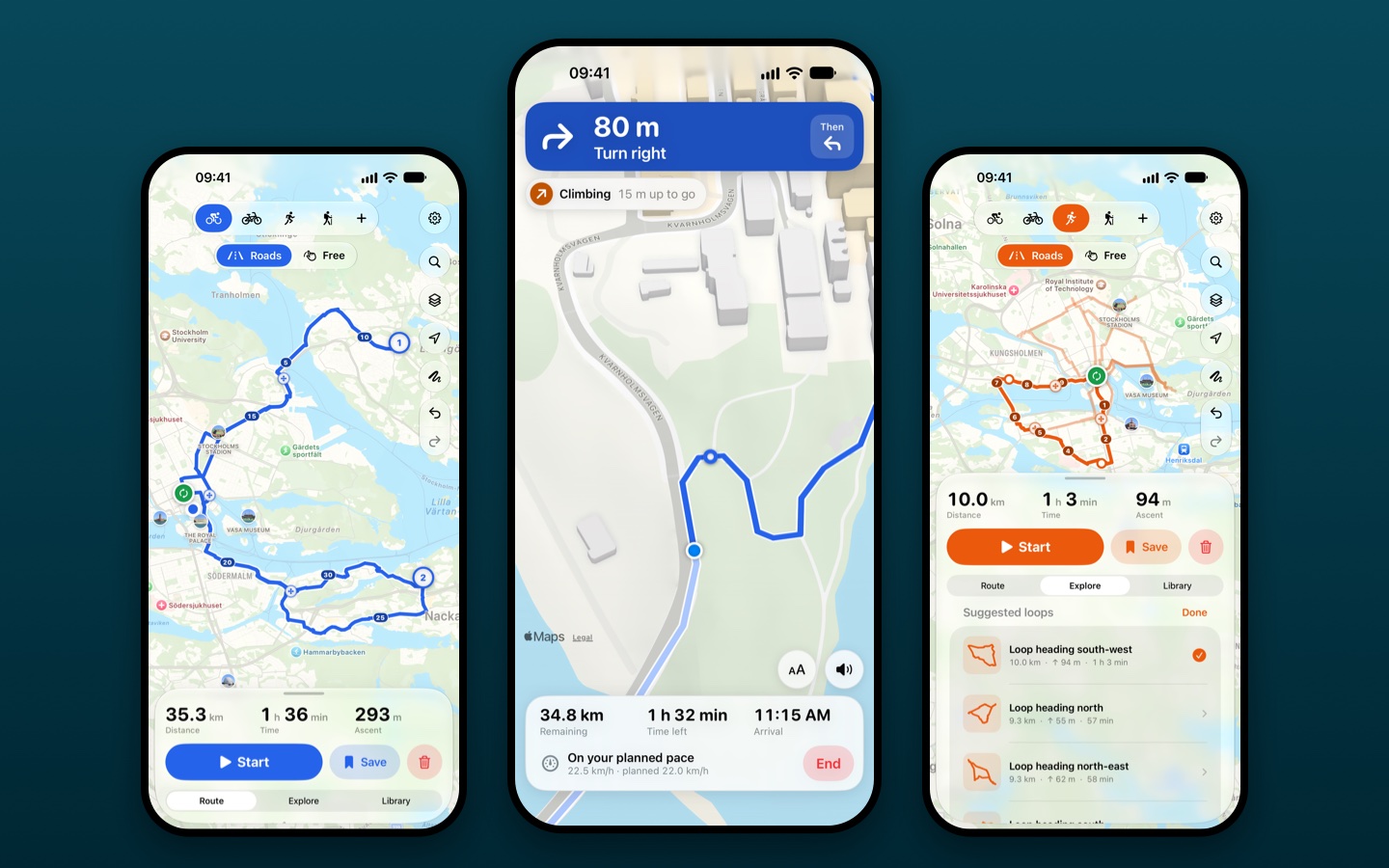
A planner that also shows you the way. You decide where to go before you leave: tap a few points and the route follows roads and paths between them, or pick a distance and get round trips that start and end where you are. The app shows the distance, an elevation profile and a time worked out from your own pace.
On the way, tap Start and the app follows you along the route: the next turn and the distance to it on screen, on the Lock Screen and spoken over your music. It records nothing unless you ask it to save your trips to Apple Health. When you want the route on a bike computer or in another app, you export it as a GPX file.
Who it is for
- Runners who want a loop of 5, 10 or 20 km from the front door, and a different one tomorrow.
- Cyclists on road, gravel or mountain bike who want to see the climb before choosing a route.
- Walkers and hikers planning a day out, also where the trail leaves the map.
- Anyone who wants a route planner without an account, a feed or a subscription.
The app in short
- Price
- Free. Plus is a one-time purchase, with no subscription: USD 4.99 in the United States, and the App Store shows the price in your country.
- Works on
- iPhone with iOS 26 or later.
- Language
- English. Metric or imperial units.
- Where
- On the App Store in 113 countries and regions. Bike routes use Apple Maps cycling directions in about forty countries, and walking directions elsewhere.
- Account
- None.
- Your data
- Routes and settings stay on your phone. Nothing is collected.
- Publisher
- Gustalabs (Daniel Gustafsson), Sweden.
What is inside
Tap out a route
Tap the map to add points. Drag a point to move it, and tap the line to add a stop. If the route took the wrong road, drag the handle in the middle of that part onto the road you meant. Tap the start marker and the route closes into a loop. Reverse it, go back to the start or make it an out-and-back, and undo anything.
Loops from where you stand
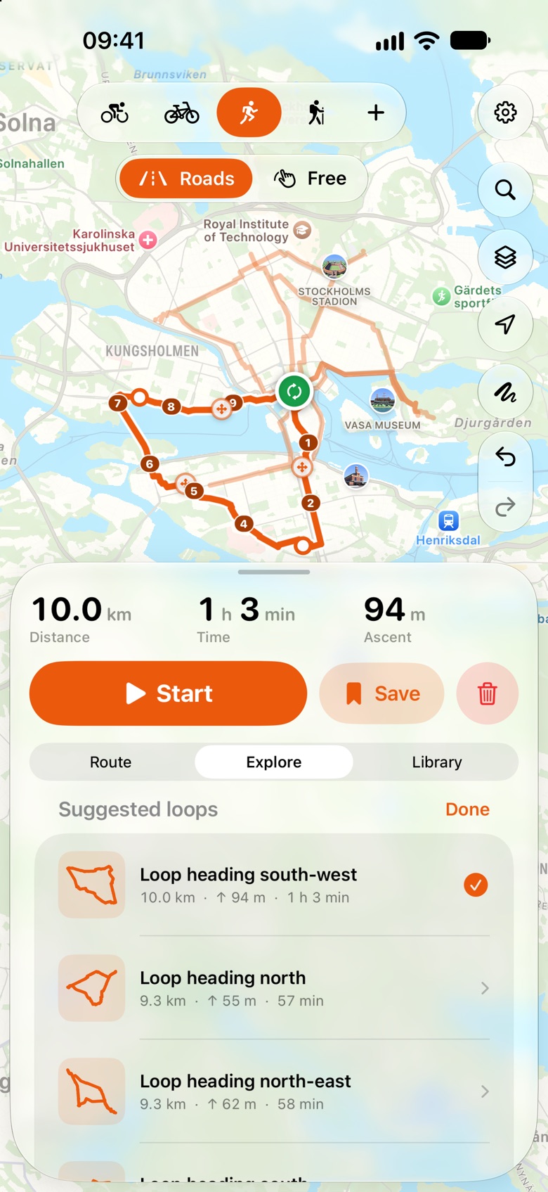
Pick a distance and get round trips from where you are, from the middle of the map or from your start. Real loops come first, and a suggestion that goes out and back the same way is labeled. Tap another suggestion to compare, then change the one you choose like any other route.
Start from me, and search
Turn on Start from me and your first tap is where you want to go: the route starts where you are. Or search for a place and get a route there.
Draw where there is no path
Draw a route with one finger and it follows roads and paths. Switch to Free to draw a line of your own across a lake, a field or a mountainside, then switch back to Roads for the rest. One route can mix both, and two fingers still move the map while you draw.
Know the climb
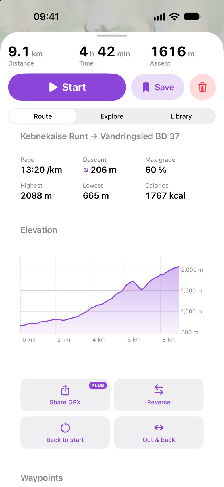
An elevation profile you can drag along while a dot follows on the map. Ascent, descent, the highest and lowest point and the steepest stretch. A time from your own pace, with extra time for climbing, and an estimate of calories.
Follow the route
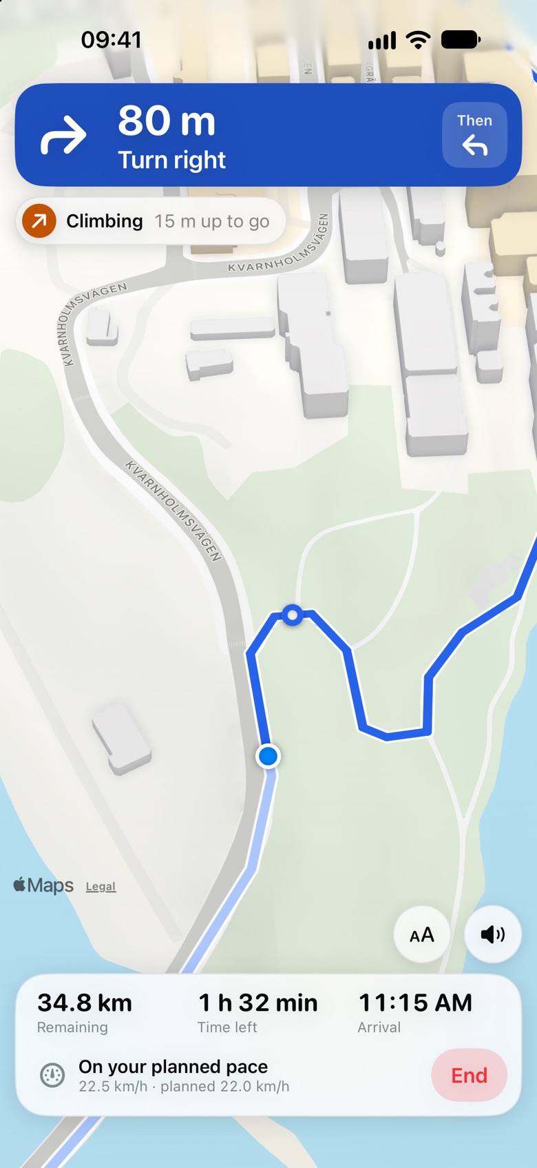
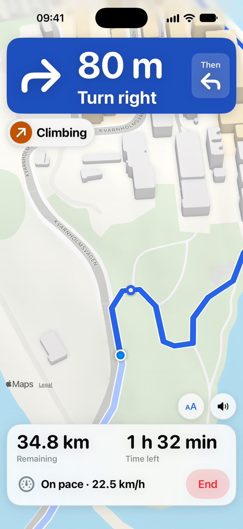
Tap Start and the map turns the way you are going. The next turn and the distance to it are on screen, on the Lock Screen and spoken over your music, also with the phone locked. You see the time left, when you arrive and whether you are ahead of or behind the pace you planned, and you get a heads-up before a climb or a descent. Leave the route and the app says so and points the way back. On a bike, turn on the large display: a bigger arrow and bigger numbers, read in a second. Following a route is free. With Plus and Good Route open on your Apple Watch, the arrow and the distance are also on your wrist, with a tap before each turn.
Activities
Road bike, gravel and MTB, running, and walking and hiking are there from the start. The plus button adds e-bike, cross-country skiing, ski touring, inline and roller skiing, horse riding, tour skating, paddling and open-water swimming.
Marked trails and maps
Find signposted hiking, cycling and mountain bike trails near the map, and marked ski tracks, skating routes and bridleways, from OpenStreetMap. Standard, terrain, hybrid and satellite maps, light or dark.
Your routes
Save a route and it opens again at once. Open GPX files from other apps, Files or Mail. The route you are working on is still there when you come back to the app.
Plus
Planning a route and following it are free, including three saved routes. Plus is a one-time purchase, with no subscription, and gives you unlimited saved routes, sharing and export as GPX for a bike computer, another app or a friend, and the Apple Watch app. It can be shared with your family through Family Sharing.
Privacy
You don't need an account. Your routes are saved on your phone. We don't collect any data about you: no analytics, no advertising and no tools from other companies in the app. The map, search and directions come from Apple Maps. Read the privacy policy and the terms.
Good to know
Routes are suggestions: roads, paths and conditions change, so follow signs and traffic rules and use your own judgment. Directions come from Apple Maps. Where it has no cycling directions, bike routes follow walking directions, which can use footpaths and stairs. Distances, climbs, times and calories are estimates.
Support
Do you have a question, found something that doesn't work, or miss something? Email support@gustalabs.com and we will answer as soon as we can. It helps if you say which iPhone and iOS version you have, and where in the world the route was.
Questions people ask
Is Good Route free?
Yes. Planning routes, following them with turn directions, finding loops and marked trails, the elevation profile, opening GPX files and three saved routes are free. Plus is a one-time purchase, with no subscription: USD 4.99 in the United States, and the App Store shows the price in your country. It gives unlimited saved routes, sharing and export as GPX, and the Apple Watch app.
Do I need an account?
No. There is no account, no sign-in and no feed. The app opens on the map and your routes are saved on your phone.
How is it different from apps such as Strava or Komoot?
Good Route plans a route and shows you the way along it. It has no social feed, no account and no subscription, and it records nothing unless you turn on Save to Apple Health. If you want to plan a loop or a route quickly, see the climb and follow it with turn directions, it does that. Its directions have no street names. If you want training statistics, navigation with street names or a community, those apps do more.
Which iPhone do I need, and where does it work?
An iPhone with iOS 26 or later. The app is in English, with metric or imperial units. It is on the App Store in 113 countries and regions, the ones where Apple Maps has directions for walking or cycling.
Why is part of my route a dashed straight line?
No cycling or walking path was found for that part, for example across water or off the trails. Move the point closer to a road or path. Or make that part a line of your own: tap the point at its end and choose "Straight line to here", or switch to Free at the top of the map and draw it.
The route took the wrong road. Do I have to start again?
No. Every part of the route has a small round handle in its middle. Drag it onto the road you meant and that part is planned again through there. You can also drag any marker, or tap the line to add a stop.
How do I get back to the start?
Tap the start marker and the route closes into a loop. A line drawn back to the start closes it too. "Undo" takes it back.
I opened the loop suggestions by mistake.
Tap "Cancel" or "Done" above the suggestions, or just carry on with your own route: as soon as you add or move a point yourself, the suggestions go away. The bin clears everything.
Can the route start where I am without tapping there first?
Yes. Turn on "Start from me" at the top of the empty map. Your first tap is then where you want to go, and the route starts at your location. The app remembers the choice. If you tap very far from where you are, the route starts at that point instead.
I can't move the map while I draw.
Use two fingers: they move and zoom the map and never draw. One finger draws.
Can the app be light when my phone is dark?
Yes. Settings (the gear) > Appearance: System, Light or Dark.
How do I plan where there is no road or path?
Switch from Roads to Free at the top of the map and draw the line with your finger, or tap for a straight line. You can draw in several parts: each one carries on from the last. One finger draws, and two fingers move and zoom the map. Free stays lit, with a glow around the map, for as long as your finger draws. Tap Done or Roads when you have finished, and the next part follows roads and paths again. One route can mix both, and each part stays the way you made it.
My activity isn't in the bar at the top. Can I add it?
Tap the plus at the end of the bar. You can add e-bike, cross-country skiing, ski touring, inline and roller skiing, horse riding, tour skating, paddling and open-water swimming, and take away the ones you don't use. Skiing and riding use walking directions from Apple Maps, which don't know ski tracks or bridleways: use "Find marked trails nearby" under Explore, or draw the part yourself. Paddling, tour skating and swimming have no roads to follow, so those routes are drawn.
Why does my bike route start with a detour?
Cycling routes follow one-way streets, so a start in a one-way street can begin by going around the block. Running and hiking routes don't.
Why does my bike route follow walking directions?
Apple Maps has cycling directions in about forty countries. Elsewhere Good Route plans bike routes the way a walker would go, and says so on the Route tab. Such a route can use footpaths and stairs, or a one-way street the wrong way, so look it over before you ride. Drag the handle in the middle of a part to send it another way.
Is gravel or MTB routed differently from road cycling?
Not yet. All bike routes use the same cycling directions from Apple Maps. The activity changes the pace used for the time, the color, and which marked trails are suggested.
Does it work without a connection?
A saved route opens without a connection. Planning a new route, searching and finding loops need one, and so does the map for areas you haven't looked at before.
Can it guide me turn by turn or record my ride?
It guides you, and it records only if you ask it to. Tap Start on a route and Good Route shows the next turn and the distance to it, says it over your music and tells you if you leave the route. It also shows the time left and whether you are ahead of or behind your planned pace. With Plus and the app open on your Apple Watch, the arrow is on your wrist. The turns are read from the shape of the route, so they have no street names and a sharp bend can be announced like a turn. Nothing about your trip is saved, unless you turn on Save to Apple Health under Settings: then each route you follow is saved to Apple Health as a workout with its distance, its time and the way you went, and with your heart rate when Good Route on your Apple Watch records it. Apps you have let into Health, such as a training log, can pick it up from there.
How exact are the climb and the time?
They are estimates. The climb comes from a terrain model with a point roughly every 20 to 40 meters, which smooths out short, steep bumps. The time comes from the pace you set under Settings. In a few areas the public terrain data is faulty; the app then says so under the elevation profile and leaves out the steepest grade.
Where are my routes saved?
On your phone. They are included in your phone's backup if you use one. Read more in the privacy policy.
I bought Plus on another phone.
Tap Restore purchase under Settings. The purchase can be shared with your family through Family Sharing.
How do I get a refund?
Purchases are handled by Apple. Ask for a refund at reportaproblem.apple.com.
Tap two places on the map
That is a route. Nothing to set up first: no account, and the app works without knowing where you are.
Get it on the App StoreMore apps from Gustalabs: Föräldraledig, for planning parental leave in Sweden, and Renoveringsboken, for the receipts of a house in Sweden. Everything from Gustalabs.